The state of Hawaii is in the news everywhere these days.
It was the second on my wish list to travel to as a teacher. I knew a lot about Hawaii because of its flowers. I love tropical flowers. But I was also interested in volcanology. Fortunately the Challenger Center Workshop presenters were awarded a workshop on the Big Island, right there in Volcanoes National Park.
The status and summary, updated. Updated news about Hawaii
Where is Hawaii?
What island are we talking about ?
What is happening? What do we know?
When I taught back in the day ,there was this movie, that we had to share with students that shared the last big eruption of the volcano. Here is a map to show which island and the location of the flow. The state of Hawaii is several islands and is still expanding. We did not have GIS or live photos like these.
If you have access to Science on a Sphere, you can easily learn
-
a theory explaining the structure of the earth’s crust and many associated phenomena as resulting from the interaction of rigid lithospheric plates that move slowly over the underlying mantle.
This is a project in some schools , museums and public places that will teach you earth science. The ring of fire is what we use to tell about volcanology.
It is here.
In learning places like museums, schools and community centers you might be able to learn about plate tectonics with a hug globe on which images are projected.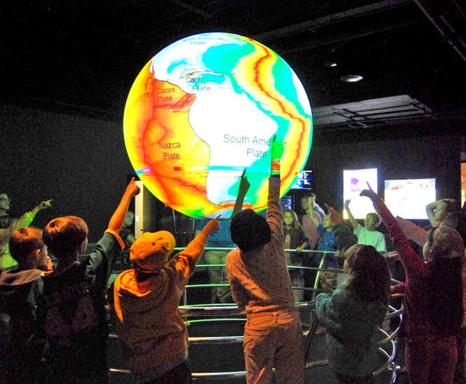
The tools that we have now to explore and learn about earth science are fantastic.
There is a laptop version. It is called Explorer
What is SOS Explorer?

Hilary Peddicord uses SOSx in the single screen
mode at Casey Middle School in Boulder, CO
SOS Explorer™ (SOSx) is a flat screen version of the widely popular Science On a Sphere® (SOS). The revolutionary software takes SOS datasets, usually only seen on a 6-foot sphere in large museum spaces, and makes them more accessible. Animated images such as atmospheric storms, climate change, and ocean temperature can be shown in SOSx, which explains sometimes complex environmental processes in a way that is simultaneously intuitive and captivating.
NOAA uses SOSx as an instrument to highlight and disseminate cutting edge science to the world through visualizations that show information provided by satellites, ground observations and computer models.
Features Include:
- Easy to use touchscreen interface for maximum interactivity
- Over 140 datasets, including real-time datasets with descriptions
- Educational videos linked to specific datasets for deeper inquiry
- Tours that create a narrative through the datasets and help users make connections
- Analysis tools to easily measure, probe, and plot data from the visualizations
- Immersive, first person experiences: walk on the Moon, pilot a submarine, or take cover from a tornado
- Stunning graphics in beautiful 4k resolution
- Dual screen or single screen configuration options
- SOSx Tour Builder that allows for the addition of new datasets and the creation of tours
- Virtual Reality add-on
- 360 degree video content
- International language support
- Compatibility with interactive projectors, screens, tables, and smartboards

Lots of people want to know how to make it Science, Technology. Engineering and Math. The lessons here are incredible for the Explorer program. You can learn using GIS from ESRI very well. The story maps are quite interesting and students could use the newspaper articles to create their own story maps. Here is an exercise for students to complete. In this exercise the student uses data to evaluate. This personalizes the experience. The students have to T H I N K and use data. I love this lesson.
When a volcano erupts, how much time do residents have to evacuate? That depends. Lava flows downhill and travels faster over steep ground. In the early 1990s, residents of Kalapana, a town in the southeastern Puna region, had days or even weeks to prepare for a lava flow that eventually covered the town. By contrast, a 1950 lava flow down the western flank of Mauna Loa reached the sea in about four hours. Although scientists monitor ground movement on the island continuously, there is no way to know how much advance notice residents living downhill of an eruption will receive.
In this lesson, you’ll begin to explore the relationships among lava flow zones, emergency shelters, and population. By the end, you’ll be ready to ask some questions that you’ll answer in the remaining lessons.
Explore the data and ask questions
When a volcano erupts, how much time do residents have to evacuate? That depends. Lava flows downhill and travels faster over steep ground. In the early 1990s, residents of Kalapana, a town in the southeastern Puna region, had days or even weeks to prepare for a lava flow that eventually covered the town. By contrast, a 1950 lava flow down the western flank of Mauna Loa reached the sea in about four hours. Although scientists monitor ground movement on the island continuously, there is no way to know how much advance notice residents living downhill of an eruption will receive.
Hawaiian folklore and art are interesting to link to the lessons. So is thinking about walking through a lava tube. What is it? What should it be like inside? Why is it called a lava tube? How long are they, and where can they be found? Why does NASA use them for training?
You can see my Volcano National Park Tour here. I will add text to the pictures. Madam Pele has many stories . I don’t think I know them all. There is music and incredible dance.